Imagine easing your skiff off a private dock, coffee in hand, and cruising straight into Little Assawoman Bay before the crowds. If you’re considering a canal‑front home in Fenwick Island, you want that lifestyle to feel effortless. The right property makes boating, sunsets, and low‑stress ownership part of your everyday. The wrong one can surprise you with shallow channels, permitting issues, or flood‑zone realities. In this guide, you’ll learn how these canals work, what the rules allow, how location affects value, and exactly what to verify before you buy. Let’s dive in.
How Fenwick’s canals work
The bay system and access
Fenwick Island’s canal network ties into Little Assawoman Bay, with connections north through the historic Assawoman Canal and south toward the Ocean City Inlet. The Assawoman Canal is a key link between Indian River Bay and Little Assawoman Bay, which shapes how you plan runs for fishing, sandbar days, or dining trips. You can read the canal’s background and regional context in the overview of the Assawoman Canal.
Local tides and survey references matter when you evaluate dock heights, lift clearances, and flood data. NOAA’s Ocean City benchmark page is a helpful reference when you’re translating MLLW or MLHW to NAVD88 during survey reviews. See NOAA’s benchmark listings for the nearest official data.
Depth and dredging today
Depth is the practical limiter for boat size. Recent state projects have targeted the Assawoman Canal and White Creek to restore safe navigation. DNREC reported work completed in mid‑2024, with a target design depth around 3 feet below MLLW in many stretches of the Assawoman Canal. That generally favors shallow‑draft skiffs, jon boats, and many center‑console boats. Deeper‑draft cruisers and sailboats are limited unless your lot fronts a deeper, actively maintained fairway. Review DNREC’s current updates on the Assawoman Canal and White Creek dredging program.
Marinas and launch options
If you plan frequent ocean runs or host larger groups, consider slip availability and ramp access. Area facilities include seasonal marinas and local public ramps throughout the Inland Bays. Many canal‑front buyers still keep a secondary slip for larger boats and use their backyard dock for day boats and PWCs.
What you can build and keep
DNREC permits and leases
In Delaware, anything placed on tidal underwater lands or extending channelward of mean low water typically needs DNREC authorization. Smaller repairs may qualify under a Statewide Activity Approval, while new or larger work can require full permits and a Subaqueous Lands Lease. Always ask for copies of active approvals and any lease tied to the dock or lift. Start with DNREC’s guide to Wetlands and Subaqueous Lands permits.
Town rules you must meet
Fenwick Island’s code limits how far docks, piers, lifts, and davits can project into canals. In canals 60 feet wide or less, docks generally may not extend beyond the bulkhead line. In wider canals there may be limited extensions, and boat lifts and davits have specific projection limits, commonly 12 feet from the bulkhead. Town building permits are required for new docks, lifts, and many shoreline structures, and Town approvals are separate from state or federal permits. Review the Town’s dock and projection rules in the Fenwick Island code.
Environmental and no‑wake constraints
Where submerged aquatic vegetation is present, pile spacing, lift types, and construction methods are often conditioned by federal and state agencies. Many approvals require a seagrass survey before work. Example permit language from the U.S. Army Corps shows how these conditions appear in practice. See a representative permit with environmental conditions for context.
Operationally, expect no‑wake zones and posted speed limits to protect shorelines and structures. For safe operation and enforcement contacts, check Delaware’s boating safety guidance.
What listings really offer
Common home and dock setups
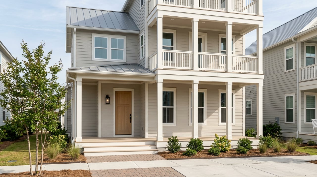
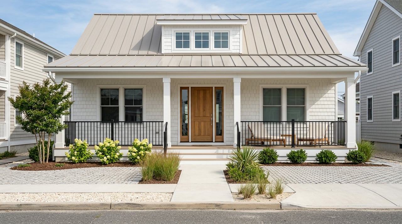
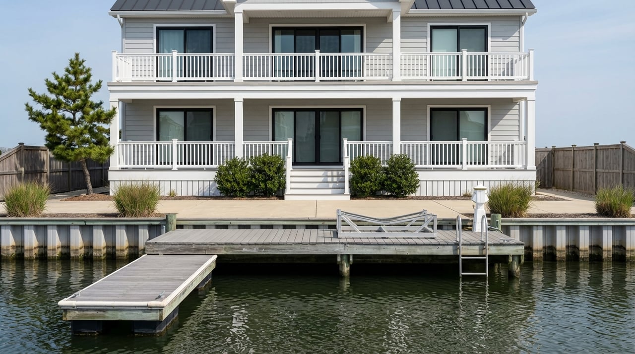
Many Fenwick canal homes are 2–3 story coastal designs with stacked rear decks oriented to the water. You’ll often see a private bulkhead, a short fixed pier with one or two finger slips, or a fixed walkway leading to a small floating dock. Where permitted, owners install uncovered boat lifts. Composite decking on bulkhead caps, outdoor showers, and under‑house storage are common upgrades that keep maintenance low and beach days easy.
Water depth and boat choice
Most buyers match the property’s canal depth to a shallow‑draft day boat. If your boating plan needs 3 to 5 or more feet of draft, verify measured depths at mean lower low water near the dock and confirm whether your lot fronts a dredged fairway or a narrower side canal. Depths can shift seasonally, so documented dredging history and maintenance responsibility are key points in your offer.
How location affects lifestyle and value
- Channel position and access. Homes on a main, state‑maintained fairway with a direct run to Little Assawoman Bay or toward the Ocean City Inlet usually command a premium versus homes on shallow, dead‑end landcuts.
- Canal width and rules. Narrow canals, defined in Town code at the 60‑foot threshold, limit how far you can project a dock or lift. Wider canals can allow slightly more over‑water structure, subject to permits.
- Exposure and fetch. Long, open reaches that face prevailing winds can see more wake action. Sheltered fingers or canals set off the main channel are often calmer for overnight moorage.
- Flood zone and elevation. Local code adopts freeboard above FEMA minimums, and the Town participates in the CRS program that can modestly reduce NFIP premiums for qualifying properties. Review local requirements and CRS context in Fenwick’s flood information resources.
- HOA and marina arrangements. In some nearby communities, the HOA controls slips, waiting lists, and assessments. Listings may note whether pier or dock maintenance is included in fees. Always confirm transferability and any special assessments before you offer.
Your due‑diligence checklist
Before you write an offer on a canal‑front property, use this checklist to protect your time and capital.
Survey and water lines. Ask for a recorded survey showing lot lines, mean high and low water lines, and bulkhead locations. Confirm any riparian rights language in the deed. Why it matters: it defines where private improvements meet public subaqueous lands. Start with DNREC’s subaqueous lands guidance.
Dock and lift authorizations. Request copies of DNREC approvals, any Subaqueous Lands Lease, and any U.S. Army Corps authorization. If a dock exists without paperwork, treat it as a red flag requiring resolution.
Elevation Certificate and FIRM data. Order the property’s FEMA panel and Base Flood Elevation, then compare the lowest floor elevation to local Chapter 88 freeboard requirements. Get a flood insurance quote based on the certificate. Pull official panels through FEMA’s Flood Map Service Center.
Bulkhead and dock inspection. Hire a qualified marine contractor to assess tie‑back integrity, cap condition, pilings, and the riprap or toe of the bulkhead. Bulkheads can be a multi‑thousand‑dollar near‑term liability, so get repair or replacement estimates early.
Dredging depth and responsibility. Ask the seller or HOA when the canal was last dredged, who pays for maintenance, and typical depths at MLLW near the dock. Confirm if the canal is in a state‑maintained project area using DNREC’s dredging updates.
HOA covenants and slip policies. Review slip assignment rules, waiting lists, transferability, and any special assessments. Confirm whether short‑term rental policies affect your intended use.
Environmental surveys. Ask whether a seagrass or SAV survey was performed at the dock. If federal review applied, request any conditions that limit lifts, pile spacing, or construction methods. See example conditions in this permit package.
Utilities confirmation. Fenwick Island properties often connect to public water and Sussex County sewer. Verify service at the parcel level using the Town’s utilities information.
Insurance quotes and underwriting. Obtain NFIP and private flood quotes using the Elevation Certificate. Confirm wind and hurricane deductibles. Fenwick’s CRS participation can modestly reduce NFIP premiums for eligible policies. Review the Town’s flood resources.
Title exceptions and easements. Confirm there are no recorded easements that restrict dock replacement or grant third‑party shoreline rights. Remember that subaqueous lands are generally held in public trust unless specifically granted.
Pro tip: When you compare surveys, permits, and flood data, align all elevations to the same vertical datum. Use NOAA benchmark data to translate between MLLW, MLHW, and NAVD88 so your measurements are apples‑to‑apples.
Dock condition and long‑term care
A well‑kept bulkhead and dock protect your shoreline and your boat. If wood or vinyl shows rot, corrosion, or undercutting at the toe, plan for repairs and ask whether an SAA can cover in‑kind work within the existing footprint. Regular inspections and clear HOA funding for shared canals help avoid surprise assessments.
The bottom line for buyers
The best canal‑front homes in Fenwick Island pair the right water depth with compliant, well‑documented docks and storm‑smart construction. Prioritize channel position, confirm permits and leases, verify flood elevations, and get eyes on the bulkhead. With the right due diligence, you can enjoy easy backyard boating and strong long‑term value.
Ready to shortlist properties with the right water and the right paperwork? Reach out to Justin Healy for local insight, private previews, and a calm, concierge path to your coastal home.
FAQs
What boat sizes work on Fenwick Island canals?
- Most canals favor shallow‑draft skiffs and many center consoles due to target design depths around 3 feet below MLLW in the Assawoman Canal; verify measured depths at the specific dock.
Do I need a permit to replace a dock in Fenwick Island?
- Yes, most work in tidal waters needs DNREC authorization and may require a Subaqueous Lands Lease; Town building permits are also required for docks and lifts.
How do flood rules affect a canal‑front purchase?
- Fenwick’s local freeboard and CRS participation influence construction requirements and NFIP premiums; confirm the Elevation Certificate and compare to local code.
Are boat lifts allowed on narrow canals in Fenwick Island?
- The Town code limits projections, with specific distance caps for lifts and davits; narrow canals have tighter rules, so check the code and existing approvals.
What should I check about dredging before I buy?
- Ask when the canal was last dredged, who pays for maintenance, and typical depths at MLLW near the dock; confirm whether the canal is in a state‑maintained project area.